


.png)


Morphological change assessment from intertidal to river-dominated zones using multiple-satellite imagery
Full Length Article “Morphological change assessment from intertidal to river-dominated zones using multiple-satellite imagery: A case study of the Vietnamese Mekong Delta”.
Understanding river bank and shoreline dynamics is important for ecological conservation, livelihood stabilization, water resources management and hazard mitigation, but this is always a difficult task because the river and coastal morphology is influenced by both natural processes and human activities. The Vietnamese Mekong Delta with its dense population of 17 million people and a complex river system under the impacts of both natural and artificial drivers was chosen as a case study to understand erosion and accretion mechanisms of deltas. Sedimentation plays a critical role in sustaining the livelihoods of population, biodiversity, and food production, but long-term and large-scale sediment dynamics studies on huge sediment starvation due to dams and sand mining were limited. Remote sensing data analysis with the cloud-computing-based Google Earth Engine for the period from 1989 to 2014 has exhibited that both regional and local drivers and hydrological characteristics of each region were responsible for river bank erosion and accretion.
In the river-dominated zone, the levels of erosion and accretion are from medium rates (1–5 m/year) to high rates (> 5 m/year), and erosion processes commonly occur along the Mekong River branch (Tien River). In the tidal-dominated zone, the river banks were quite stable, and erosion processes with medium levels mainly occurred at river segments near estuaries, except for the Ba Lai estuary. In the coastal zone, erosion and sedimentation alternatively took place at a rapid rate. The main erosion mechanisms were toe-scour and lower slope erosion in the river-dominated zone, the tidal fluctuation-related soil collapses in the tidal-dominated zone, and monsoon-influenced erosion in the coastal zone. Engineering or alternative solutions should be chosen appropriately to maximize the efficiency of protection for each region, while more monitoring programs are required to provide more reliable data to study erosion and sedimentation processes.
Resource:
https://www.sciencedirect.com/science/article/abs/pii/S2352485518306455#!
Morphological change assessment from intertidal to river-dominated zones using multiple-satellite imagery
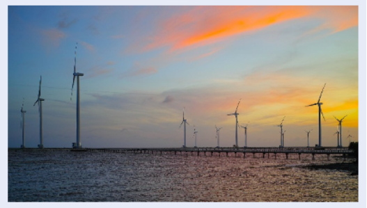
Đánh giá tiềm năng gió và tối ưu hoá tua-bin
Bài báo “Đánh giá tiềm năng gió và tối ưu hoá tua-bin trong trang trại điện gió sử dụng phần mềm WAsP và WindPRO”.
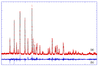
Đan cài ion Na+ vào olivine LiFePO4
Bài báo “Nghiên cứu quá trình đan cài ion Na+ vào cấu trúc olivine LiFePO4”.
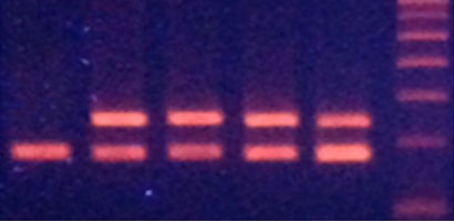
Chế tạo hạt Fe3O4 tách chiết DNA
Bài báo “Chế tạo hạt nano Fe3O4 nhiều kích thước ứng dụng trong tách chiết DNA từ mẫu sinh học”.
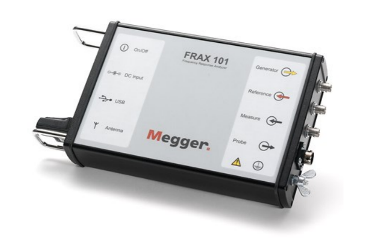
Thông số điện máy biến áp
Bài báo “Nhận dạng thông số điện máy biến áp lực áp dụng chẩn đoán sự cố”.
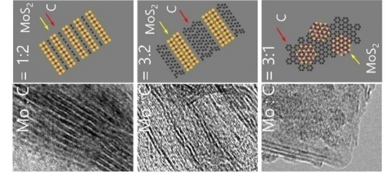
Controllable synthesis of MoS2/graphene low-dimensional nanocomposites
Full Length Article “Controllable synthesis of MoS2/graphene low-dimensional nanocomposites and their electrical properties”
Điều phối dòng công suất cho lưới điện Microgrid
Bài báo “Mô phỏng điều phối dòng công suất cho lưới điện Microgrid sử dụng hệ thống năng lượng mặt trời và hệ thống pin lưu trữ năng lượng”
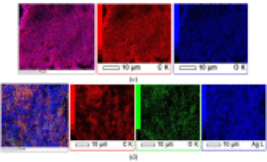
Synthesis of silver/reduced graphene oxide for antibacterial activity
Full Length Article “Synthesis of silver/reduced graphene oxide for antibacterial activity and catalytic reduction of organic dyes”.
Mô phỏng thiết bị hạn chế dòng ngắn mạch
Bài báo “Mô phỏng thiết bị hạn chế dòng ngắn mạch kiểu máy biến áp trên lưới điện phân phối 22kv tại Tp. Hồ Chí Minh”.
- Ngày sách Việt Nam 21/4/2024
- Cuộc thi thiết kế bìa sách 2024
- Ngày hội văn hóa đọc lần V
- Vòng Sơ Khảo Cuộc Thi Đại Sứ Văn Hóa Đọc Năm 2024
- Cuộc Thi Ảnh “Khoảnh Khắc VNUHCM Libraries”
- Ngày hội văn hóa đọc lần II
- Ngày hội văn hóa đọc lần IV
- Ngày hội văn hóa đọc lần III
- Tiếp GS Omer Mert Denizci, Trường ĐH Marmara Thổ Nhĩ Kỳ
- Tiếp Cô Claudia Tarzariol Từ The University Of Trento, Italy (Unitrento)
- Tiến sĩ kiều bào Mỹ tặng sách trị giá 150.000 USD cho sinh viên bách khoa
- Khảo sát ý kiến bạn đọc
-
Trực tuyến:14
-
Hôm nay:1873
-
Tuần này:15569
-
Tuần trước:30809
-
Tháng trước:43409
-
Tất cả:3979238
.png "Logo Bottom")